Discover Wetlands on World Wetlands Day 2017
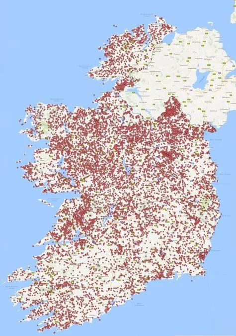
The first Map of Irish Wetlands has recently been completed following three years of research and data compilation on a voluntary basis by wetland scientists Dr Peter Foss and Dr Patrick Crushell.
The on-line Map of Irish Wetlands shows the location of more than 12,600 wetland sites in Ireland. The map has been created and made available to the public free of charge without the assistance of any public funding. Upwards of two hundred individuals refer to the map each month including researchers, students, land use professionals, and the general public.
The map is displayed via the Google Maps interface and can be accessed from any on-line device, without the need for special software. The Map of Irish Wetlands shows the location and provides summary information on protected and well known wildlife sites such as Clara Bog, Pollardstown Fen, or Dublin Bay. The map also provides information on lesser known wetlands that are important to local wildlife including cutover bogs, wet woodlands, farm ponds, and even golf course ponds. According to Dr. Crushell “These small wetlands all form part of a national network of sites that support a great variety of specialist plants and animals adapted to living in wetland environments”.
This network, which forms a key part of Ireland’s natural history resource, has been identified for the first time by the Map of Irish Wetlands project. The value of wetlands in providing services to society is increasingly being recognised by concepts such as 'green capital' and 'green infrastructure'. However, the team behind the Map of Irish Wetlands believe that planning authorities and other state agencies charged with the protection of our 'green capital' should be doing more to identify and evaluate the resource. “To date only counties Kildare and Louth have undertaken the necessary surveys to characterise and evaluate the complete wetland resource they have, something urgently needed across many other counties in Ireland” says Dr. Crushell.
In the meantime the information presented on the map will continue to be refined by the map team. It is hoped, subject to finding a suitable sponsor or partner, that the functionality of the map will be enhanced during 2017 to allow users to easily search features of the wetland map and overlay it on other available datasets such as soil maps or land cover maps.
“Information on new or existing sites is always welcome, so if you would like to contribute to this wetland mapping project get in touch” says Dr. Crushell.
To celebrate World Wetlands Day on 2 February, Wetland Surveys Ireland are hosting a ‘Name the Wetlands' competition. To take part go to the WSI Facebook page for further details.
For further Information:
WetlandSurveysIreland.com; Tel: 064 6642524; Email: info@wetlandSurveysIreland.com
Link to Map of Irish Wetlands


