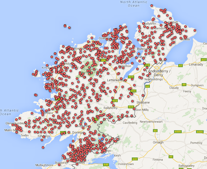
New wetland map for County Donegal
As part of the project to map Ireland's wetlands, a preliminary mapping survey of all wetlands (both known and potential wetland sites) in County Donegal has just been completed.
A significant number of additional wetlands have been located in the county bringing the wetland site total recorded in the county to 880.
The wetland sites mapped in Donegal are those which have been reported in wide range of published sources, and previously unknown sites located through an aerial photographic analysis combined with sub soils data.
Prior to this research project 126 wetland sites had been identified within the county. This mapping project has located an additional 754 wetland sites throughout the county, bringing the total number to sites identified to 880. Wetlands included on the map are areas of blanket bog, fen, swamp, wet woodland, ponds, lakes and rivers.
The majority of the “new” sites identified have limited associated information on the wetland habitats that are likely to occur on the sites. County wetland surveys are required to address this information deficit.
New wetland photographs and an acknowledgment to the person who submitted the image, for 1350 wetlands were also added to a number of county maps including: Carlow, Cavan, Dublin, Kildare, Laois, Leitrim, Longford, Mayo, Monaghan, Meath, Offaly, Sligo, Wicklow, Waterford, Wexford and Roscommon, together with some additional sites in these counties.
There are still many wetlands without a photograph - so if you would like to send on a photograph of a site or take a snap shot on a mobile device, feel free to email on your photos to WetlandSurveysIreland@gmail.com. All photographs are now made copyright of the photographer and acknowledged on the Wetland Map. If possible please include the Wetland Map site code to make sure we know which site you are referring to.
Completion of the Donegal wetland identification project means that only one further Irish county, Galway needs to be assessed and the Map of Irish Wetlands will display a complete draft Irish wetland inventory. We hope to work on Galway completed in the near future.
The Map of Irish Wetlands now displays a total of 11,280 wetland sites for Ireland.

